

This week, the weather forecast predicts plenty of rain for the Greater Victoria region.
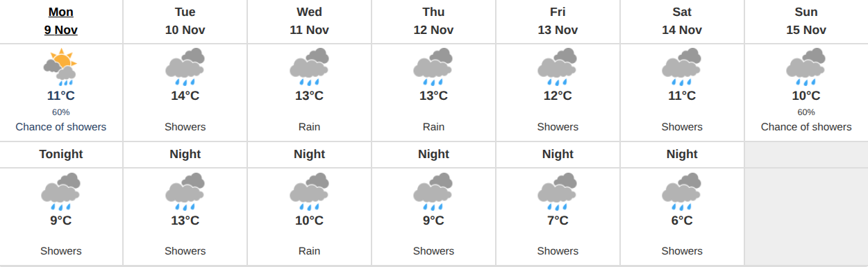
According to Environment Canada, Monday, November 9th will bring a mix of sun and cloud to the area with a 60% chance of showers predicted for the late afternoon. The high is projected to be around 11°C, while the overnight low will be 9°C.
Tuesday’s forecast predicts showers throughout the day with a high of 14°C—the warmest of the week. Overnight, temperatures will drop down to around 13°C.
On Wednesday, the forecast calls for rain throughout the day and a high of 13°C. Temperatures will drop to around 10°C overnight.
Thursday, rain is once again predicted throughout the day, and the high will remain at around 13°C, with the overnight low projected at around 9°C.
On Friday, Environment Canada predicts the week’s rain will turn to showers, and the daytime high will be around 12°C. Overnight, temperatures will drop down to around 7°C in the capital region.
Throughout the weekend, the forecast predicts the precipitation will continue and will be paired with the coolest temperatures of the week.
Saturday’s forecast calls for showers and a high of 11°C. On Sunday, a 60% chance of showers has been predicted, with a high of 10°C—the coolest of the week. The overnight low throughout the weekend will be around 6°C.
Up-island, the rainn will be more severe, according to Environment Canada.
A special weather statement has been released by the national authority, predicting a series of storm systems that will bring mass precipitation to some regions.
A series of strong fall storms is expected to bring significant rainfall and strong winds to parts of the BC coast this week.
From Tuesday through Thursday, some regions of Vancouver Island will be impacted by a strong and potent series of storms. Affected communities will include those surrounding Tofino, Port Renfrew, Port Alberni, Nanaimo, Comox, the Cowichan Valley, Port McNeill and more.
These storms will bring with them a prolonged period of heavy rainfall.
“Significant rainfall accumulations are expected, with upslope terrain and higher elevations receiving the heaviest amounts of precipitation,” reads Environment Canada’s special weather statement.
“This rainfall event comes on the heels of several low pressure systems that have moved through the region in recent days, already bringing substantial amounts of precipitation to parts of the coast.”
The weather authority noted that there is uncertainty regarding exact rainfall amounts, and that rainfall warnings will be issued as the situation becomes clearer.
Some areas may also be impacted by gusty southerly winds during this event.
“The anticipated high precipitation rates could lead to water pooling in areas with poor drainage, exacerbating localized flooding concerns,” reads the statement.
“Communities with historically lower drainage capacity, as well as areas that have already received significant rainfall should be particularly vigilant.”
Environment Canada suggests that residents in impacted regions take the time to ensure that their storm drains are clear of leaves and debris prior to Tuesday.
💬 Join the conversation
No comments yet — be the first to start the conversation